This project was funded by the Australian Government ($175,000). Australian Government funding was provided through the National Water Grid Fund.

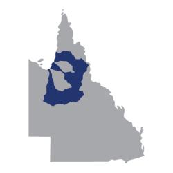
This project looked at the agricultural potential of 3 catchments in Queensland.
Project overview
This project looked at the agricultural potential of 3 catchments in Queensland. The catchments were Mitchell, Flinders and Gilbert. Alluvium Consulting undertook this work. They looked at key considerations, knowledge gaps and next steps.
This project built on extensive previous analysis by CSIRO through:
- the Flinders and Gilbert Agricultural Resource Assessment
- the Northern Australia Water Resource Assessment, which included the Mitchell catchment.
Goals of the assessment
Set criteria measured areas for sustainable agricultural development. The consultants compiled key relevant information from:
- previous studies
- dentified knowledge gaps and constraints.
They also provided extra economic analysis of key crop types.
Outcomes of the assessment
Smaller spread out developments could provide better opportunities than larger irrigation schemes. Based on the following constraints:
- limited road and rail networks
- regional soils
- temperature and water availability
- needing to ensure developments are environmentally sustainable.
Produced maps showed what land areas are more suitable for potential development. The maps show where extra research is needed to guide future development decisions.
Knowledge gaps were also identified across a range of subject areas. These included gaps in environmental, cultural and social knowledge and data. There were also gaps in understanding soils, climate, hydrology and market opportunities.
Key project benefits
Learn more
- Discover our Science Program.
- Request the Strategic assessment of sustainable agricultural development potential for Mitchell, Flinders and Gilbert catchments from the Queensland Government.
- Read the CSIRO North Australian Water Resource Assessment.
- Read the CSIRO Flinders and Gilbert Agricultural Resource Assessment.

